Geolocate

Manta topographic map

Click on the map to display elevation.

About this map
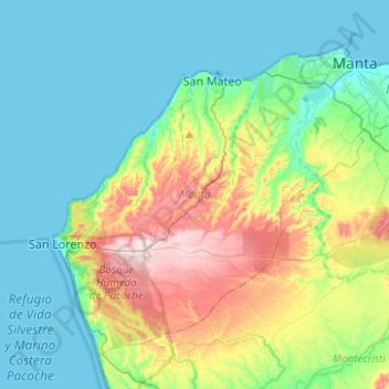
Name: Manta topographic map, elevation, terrain.

Location: Manta, Manabí, Ecuador (-1.13438 -80.91277 -0.92959 -80.65824)

Average elevation: 335 ft

Minimum elevation: -3 ft

Maximum elevation: 1,270 ft

Other topographic maps

Click on a map to view its topography, its elevation and its terrain.
Solano

Ecuador > Manabí > Pichincha > Pichincha

Average elevation: 230 ft

Santa Ana

Ecuador > Manabí > Santa Ana

Average elevation: 463 ft

La Union

Ecuador > Manabí > El Carmen > Santa María

Average elevation: 381 ft

Cordillera de Balzar

Ecuador > Manabí > Bolívar > Membrillo

Average elevation: 1,243 ft

Cojimíes

Ecuador > Manabí > Pedernales

Average elevation: 3 ft

Gear up for your next adventure:

🌡️Handheld Weather Meters - Measure wind, temp, and pressure for safe mountain travel
🔭Compact Binoculars - HD vision for scouting terrain and identifying distant landmarks
🪶Paracord Bracelet - Survival bracelet with built‑in tools
😴Insulated Sleeping Pads - Compact and warm pads for high-elevation camping
🚗GPS Dash Cams - Record your scenic drives through mountain passes and canyons

As an Amazon Associate, this site earns from qualifying purchases at no extra cost to you.