Geolocate

Taal topographic map

Click on the map to display elevation.

About this map

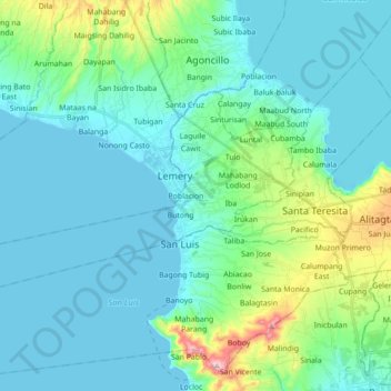
Name: Taal topographic map, elevation, terrain.

Location: Taal, Batangas, Calabarzon, 4208, Philippines (13.83039 120.79803 13.92103 120.97258)

Average elevation: 194 ft

Minimum elevation: 0 ft

Maximum elevation: 1,178 ft

Gear up for your next adventure:

🧭Outdoor Navigation Book - Learn advanced navigation skills
🔦Compact Flashlight - Reliable flashlight for emergencies
😴Insulated Sleeping Pads - Compact and warm pads for high-elevation camping
🧴Hand Sanitizer - Keep hands clean while hiking
🧤Tactile Hiking Gloves - Keep hands warm while operating GPS and smartphone screens

As an Amazon Associate, this site earns from qualifying purchases at no extra cost to you.