Geolocate

Shetland topographic map

Click on the map to display elevation.

About this map

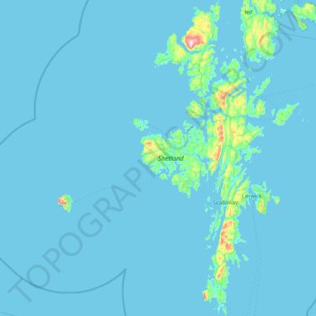
Name: Shetland topographic map, elevation, terrain.

Location: Shetland, Scotland, United Kingdom (59.85227 -1.70414 60.63958 -1.04900)

Average elevation: 36 ft

Minimum elevation: -10 ft

Maximum elevation: 1,447 ft

Other topographic maps

Click on a map to view its topography, its elevation and its terrain.

Boddam

United Kingdom > Scotland > Shetland > Dunrossness

Average elevation: 85 ft

Island

United Kingdom > Scotland > Shetland > Mid Yell

Average elevation: 66 ft

Sandness

United Kingdom > Scotland > Shetland

Average elevation: 157 ft

The Taing

United Kingdom > Scotland > Shetland > Saxa Vord > Norwick

Average elevation: 167 ft

Gear up for your next adventure:

Solar GPS Watches - Advanced multisport watches with built-in topographic maps
🛌Ultralight Sleeping Bags - Compact down bags for cold nights in the wilderness
🪓Survival Multi‑Tool - Versatile tool for camp and trail tasks
😴Insulated Sleeping Pads - Compact and warm pads for high-elevation camping
🪄Magnetic Compass - Accurate compass for navigation

As an Amazon Associate, this site earns from qualifying purchases at no extra cost to you.