Geolocate

Bridgeman topographic map

Click on the map to display elevation.

About this map

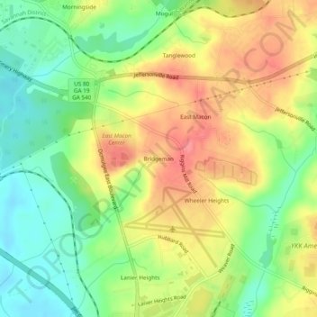
Name: Bridgeman topographic map, elevation, terrain.

Location: Bridgeman, Macon, Bibb County, Georgia, 31217, United States (32.81153 -83.58573 32.85153 -83.54573)

Average elevation: 377 ft

Minimum elevation: 259 ft

Maximum elevation: 502 ft

Gear up for your next adventure:

🧣Merino Neck Gaiters - Multi-functional headwear for wind and sun protection
🛡️Insect Repellent - Protection against bugs during outdoor activities
🧭Hiking Compass - Precision compass for reliable navigation in the wilderness
📡Handheld GPS Device - Reliable handheld GPS for outdoor navigation
🛠️Outdoor Gear Repair Kit - Essential tools to fix gear on the trail

As an Amazon Associate, this site earns from qualifying purchases at no extra cost to you.