Geolocate
👉 Easily get elevation data in JSON, GeoTIFF and KML formats using Elevation API
Thank you for supporting this site ❤️
Make a donation

Edendale topographic map

Click on the map to display elevation.

About this map

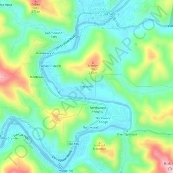
Name: Edendale topographic map, elevation, terrain.

Location: Edendale, Sonoma County, California, 95462, United States (38.46491 -123.02278 38.50491 -122.98278)

Average elevation: 295 ft

Minimum elevation: -3 ft

Maximum elevation: 984 ft

Sonoma County trails, hiking, mountain biking, running and outdoor activities

Gear up for your next adventure:

❄️Traction Cleats - Prevent slips on icy trails during winter hikes
GPS Sports Watch - GPS watch for running, hiking and training
🌐World Map Poster - Decorative world maps with topographic info
📷Action Camera - Capture your outdoor adventures in HD
📚USA Hiking Guide Books - Top trail guides and map books

As an Amazon Associate, this site earns from qualifying purchases at no extra cost to you.