
Make a donation
Gear up for your next adventure:
As an Amazon Associate, this site earns from qualifying purchases at no extra cost to you.
Hautes-Alpes topographic map
Click on the map to display elevation.
Make a donation
Gear up for your next adventure:
As an Amazon Associate, this site earns from qualifying purchases at no extra cost to you.
Hautes-Alpes
Hautes-Alpes is located in the Alps mountain range. The average elevation is over 1000 m, and the highest elevation is over 4000 m. The only three sizable towns are Gap, Briançon, and Embrun, which was a subprefecture until 1926.
Make a donation
Gear up for your next adventure:
As an Amazon Associate, this site earns from qualifying purchases at no extra cost to you.
About this map
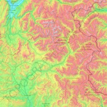
Name: Hautes-Alpes topographic map, elevation, terrain.
Average elevation: 5,351 ft
Minimum elevation: 650 ft
Maximum elevation: 12,976 ft
Make a donation
Gear up for your next adventure:
As an Amazon Associate, this site earns from qualifying purchases at no extra cost to you.