
Make a donation
Gear up for your next adventure:
As an Amazon Associate, this site earns from qualifying purchases at no extra cost to you.
Feldbach topographic map
Click on the map to display elevation.
Make a donation
Gear up for your next adventure:
As an Amazon Associate, this site earns from qualifying purchases at no extra cost to you.
About this map
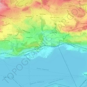
Name: Feldbach topographic map, elevation, terrain.
Location: Feldbach, Hombrechtikon, Bezirk Meilen, Zürich, 8714, Schweiz (47.22092 8.76553 47.26092 8.80553)
Average elevation: 1,483 ft
Minimum elevation: 1,319 ft
Maximum elevation: 1,834 ft
Make a donation
Gear up for your next adventure:
As an Amazon Associate, this site earns from qualifying purchases at no extra cost to you.
Other topographic maps
Click on a map to view its topography, its elevation and its terrain.
Zürichsee
Schweiz > Zürich > Bezirk Meilen
Das schmale Tal, in dem der See liegt, ist auf der Südwestseite von den Höhenzügen des Etzel und des Albis und auf der Nordostseite von der Hügellandschaft des Zürcher Oberlandes und vom Pfannenstiel flankiert. An beiden Talhängen liegen Hangterrassen, die von Seitenmoränen gebildet worden sind. Der…
Average elevation: 1,814 ft