Geolocate

Mokane topographic map

Click on the map to display elevation.

About this map

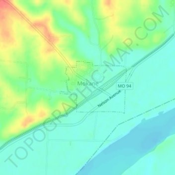
Name: Mokane topographic map, elevation, terrain.

Location: Mokane, Callaway County, Missouri, United States (38.67038 -91.87992 38.67847 -91.86672)

Average elevation: 561 ft

Minimum elevation: 502 ft

Maximum elevation: 682 ft

Callaway County trails, hiking, mountain biking, running and outdoor activities

Other topographic maps

Click on a map to view its topography, its elevation and its terrain.

Hams Prairie

United States > Missouri > Callaway County

Average elevation: 810 ft

Portland

United States > Missouri > Callaway County

Average elevation: 581 ft

Gear up for your next adventure:

🧭Pro Hiking Compasses - High-accuracy liquid-filled compasses for topographic orientation
📱Solar Portable Charger - Solar power bank for charging devices off‑grid
🛠️Outdoor Gear Repair Kit - Essential tools to fix gear on the trail
❄️Traction Cleats - Prevent slips on icy trails during winter hikes
🧦Merino Wool Socks - Moisture-wicking, blister-preventing socks for long treks

As an Amazon Associate, this site earns from qualifying purchases at no extra cost to you.