
Make a donation
Gear up for your next adventure:
As an Amazon Associate, this site earns from qualifying purchases at no extra cost to you.
Cordast topographic map
Click on the map to display elevation.
Make a donation
Gear up for your next adventure:
As an Amazon Associate, this site earns from qualifying purchases at no extra cost to you.
Cordast
Cordast liegt auf 607 m ü. M., zweieinhalb Kilometer südwestlich von Gurmels und acht Kilometer nördlich der Kantonshauptstadt Freiburg (Luftlinie). Das Dorf erstreckt sich auf einem Hochplateau zwischen dem Biberental im Nordwesten und dem Schiffenensee im Südosten, am Westfuss des Bulliardholzes, im nördlichen Freiburger Mittelland. Die ehemalige Gemeindefläche betrug rund 3,2 km². Das Gebiet umfasste das Plateau von Cordast, reichte im Osten auf das Bulliardholz (668 m ü. M.), im Norden in die Talmulde des Cordastbaches und auf den Höhenrücken Lengi Zelg (610 m ü. M.), im Südwesten in die Waldhöhen Monterschuwald (667 m ü. M.) und Bouley (666 m ü. M.) und im Südosten bis ins Einzugsgebiet des Schiffenensees.
Make a donation
Gear up for your next adventure:
As an Amazon Associate, this site earns from qualifying purchases at no extra cost to you.
About this map
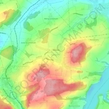
Name: Cordast topographic map, elevation, terrain.
Location: Cordast, Gurmels, Seebezirk, Freiburg, 1792, Schweiz (46.85563 7.12844 46.89563 7.16844)
Average elevation: 1,946 ft
Minimum elevation: 1,726 ft
Maximum elevation: 2,224 ft
Make a donation
Gear up for your next adventure:
As an Amazon Associate, this site earns from qualifying purchases at no extra cost to you.
Other topographic maps
Click on a map to view its topography, its elevation and its terrain.
Murten
Schweiz > Freiburg > Seebezirk
Murten liegt auf 453 m ü. M., 14 km nördlich der Kantonshauptstadt Freiburg (Luftlinie). Die Stadt erstreckt sich auf einer rund 20 m hohen Anhöhe am Südostufer des Murtensees, östlich der Mündung des von Münchenwiler herkommenden Baches, im nördlichen Freiburger Mittelland.
Average elevation: 1,575 ft