Geolocate

Haflong topographic map

Click on the map to display elevation.

About this map

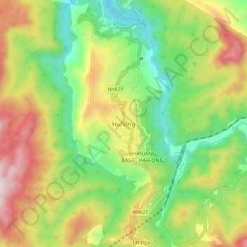
Name: Haflong topographic map, elevation, terrain.

Location: Haflong, Dima Hasao, Assam, 788819, India (25.12450 92.97760 25.20450 93.05760)

Average elevation: 1,991 ft

Minimum elevation: 984 ft

Maximum elevation: 3,720 ft

Other topographic maps

Click on a map to view its topography, its elevation and its terrain.

Jatinga

India > Assam > Haflong > Harangajao

Average elevation: 2,031 ft

Gear up for your next adventure:

🦺Reflective Outdoor Gear - Safety gear for low‑light conditions
Backpacking Tent - Lightweight and durable tent for multi‑day hikes
👟Trail Running Shoes - Lightweight shoes for trail runners
📶Satellite Messenger - Communication device off‑grid
🦶Hiking Gaiters - Keep debris and water out of your boots

As an Amazon Associate, this site earns from qualifying purchases at no extra cost to you.