
Thank you for supporting this site ❤️
Make a donation
Make a donation
Gear up for your next adventure:
As an Amazon Associate, this site earns from qualifying purchases at no extra cost to you.
Chitawira topographic map
Click on the map to display elevation.
Thank you for supporting this site ❤️
Make a donation
Make a donation
Gear up for your next adventure:
As an Amazon Associate, this site earns from qualifying purchases at no extra cost to you.
About this map
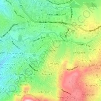
Name: Chitawira topographic map, elevation, terrain.
Location: Chitawira, Blantyre, Southern Region, Malawi, Malawi (-15.83210 35.00792 -15.79210 35.04792)
Average elevation: 3,625 ft
Minimum elevation: 3,310 ft
Maximum elevation: 4,081 ft
Thank you for supporting this site ❤️
Make a donation
Make a donation
Gear up for your next adventure:
As an Amazon Associate, this site earns from qualifying purchases at no extra cost to you.