Geolocate

Pallikkara topographic map

Click on the map to display elevation.

About this map

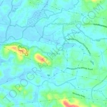
Name: Pallikkara topographic map, elevation, terrain.

Location: Pallikkara, Kunnathunad, Ernakulam, Kerala, 683565, India (10.00564 76.38332 10.04564 76.42332)

Average elevation: 39 ft

Minimum elevation: -20 ft

Maximum elevation: 213 ft

Other topographic maps

Click on a map to view its topography, its elevation and its terrain.

Pulluvazhy kandam kulam

India > Kerala > Kunnathunad > Ambalampady

Average elevation: 112 ft

Pettamala

India > Kerala > Kunnathunad

Average elevation: 75 ft

Rayamangalam

India > Kerala > Kunnathunad > Ambalampady

Average elevation: 102 ft

Vengola

India > Kerala > Kunnathunad > Perumbavoor

Average elevation: 75 ft

Kadambrayar river

India > Kerala > Kunnathunad > Manakkakadavu

Average elevation: 30 ft

Umma Chira, Pulluvazhi

India > Kerala > Kunnathunad > Pulluvazhi

Average elevation: 89 ft

Vadavukode

India > Kerala > Kunnathunad > Meempara

Average elevation: 69 ft

Gear up for your next adventure:

🧯Portable Fire Pit - Compact fire pit for camping spots
❄️Traction Cleats - Prevent slips on icy trails during winter hikes
📦Dry Bags Set - Waterproof storage for electronics and clothes
🌡️Portable Weather Meter - Track weather conditions on the trail
🪶Multi‑Purpose Knife - Useful blade for camp and trail

As an Amazon Associate, this site earns from qualifying purchases at no extra cost to you.