
Make a donation
Gear up for your next adventure:
As an Amazon Associate, this site earns from qualifying purchases at no extra cost to you.
Heven topographic map
Click on the map to display elevation.
Make a donation
Gear up for your next adventure:
As an Amazon Associate, this site earns from qualifying purchases at no extra cost to you.
Heven
Von April bis Oktober verkehrt zwischen dem Hevener und dem Herbeder Ruhrufer in Höhe der Burgruine Hardenstein die Hardenstein. Es handelt sich um eine Passagierfähre für Fußgänger und Radfahrer.
Make a donation
Gear up for your next adventure:
As an Amazon Associate, this site earns from qualifying purchases at no extra cost to you.
About this map
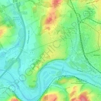
Name: Heven topographic map, elevation, terrain.
Average elevation: 328 ft
Minimum elevation: 226 ft
Maximum elevation: 531 ft
Make a donation
Gear up for your next adventure:
As an Amazon Associate, this site earns from qualifying purchases at no extra cost to you.
Other topographic maps
Click on a map to view its topography, its elevation and its terrain.
Make a donation
Gear up for your next adventure:
As an Amazon Associate, this site earns from qualifying purchases at no extra cost to you.