
Make a donation
Gear up for your next adventure:
As an Amazon Associate, this site earns from qualifying purchases at no extra cost to you.
Central topographic map
Click on the map to display elevation.
Make a donation
Gear up for your next adventure:
As an Amazon Associate, this site earns from qualifying purchases at no extra cost to you.
About this map
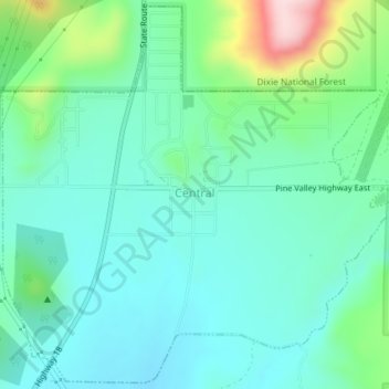
Name: Central topographic map, elevation, terrain.
Location: Central, Washington County, Utah, United States (37.40240 -113.64253 37.43058 -113.60594)
Average elevation: 5,318 ft
Minimum elevation: 5,082 ft
Maximum elevation: 6,089 ft
Washington County trails, hiking, mountain biking, running and outdoor activities
Make a donation
Gear up for your next adventure:
As an Amazon Associate, this site earns from qualifying purchases at no extra cost to you.
Other topographic maps
Click on a map to view its topography, its elevation and its terrain.
Silver Reef
United States > Utah > Washington County > Leeds
Silver Reef is close to the western border of the Colorado Plateau and about 15 miles (24 km) northeast of St. George and 1 mile (1.6 km) west of Leeds. Dixie National Forest, Leeds Creek, the White Reef, and the Pine Valley Mountain Wilderness lie directly west of Silver Reef. The Pine Valley Mountain…
Average elevation: 3,888 ft
Gunlock
United States > Utah > Washington County
The community lies on the Santa Clara River, northwest of the Red Mountains along local roads, northwest of the city of St. George, the county seat of Washington County. Its elevation is 3,658 feet (1,115 m). Although Gunlock is unincorporated, it has a post office, with the ZIP code of 84733.
Average elevation: 3,970 ft
Make a donation
Gear up for your next adventure:
As an Amazon Associate, this site earns from qualifying purchases at no extra cost to you.
Hurricane
United States > Utah > Washington County > Hurricane > Hurricane
Average elevation: 3,527 ft
Make a donation
Gear up for your next adventure:
As an Amazon Associate, this site earns from qualifying purchases at no extra cost to you.
Make a donation
Gear up for your next adventure:
As an Amazon Associate, this site earns from qualifying purchases at no extra cost to you.