
Lommersum topographic map
Interactive map
Click on the map to display elevation.
About this map
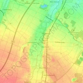
Name: Lommersum topographic map, elevation, terrain.
Average elevation: 469 ft
Minimum elevation: 361 ft
Maximum elevation: 548 ft
Other topographic maps
Click on a map to view its topography, its elevation and its terrain.
Weilerswist
Deutschland > Nordrhein-Westfalen > Kreis Euskirchen > Weilerswist
Weilerswist, Kreis Euskirchen, Nordrhein-Westfalen, Deutschland
Average elevation: 423 ft
Bodenheim
Deutschland > Nordrhein-Westfalen > Kreis Euskirchen > Weilerswist
Bodenheim, Lommersum, Weilerswist, Kreis Euskirchen, Nordrhein-Westfalen, 53879, Deutschland
Average elevation: 489 ft