Geolocate

Fairview topographic map

Click on the map to display elevation.

About this map

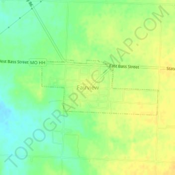
Name: Fairview topographic map, elevation, terrain.

Location: Fairview, Newton County, Missouri, United States (36.81329 -94.09714 36.82182 -94.07461)

Average elevation: 1,283 ft

Minimum elevation: 1,237 ft

Maximum elevation: 1,319 ft

Newton County trails, hiking, mountain biking, running and outdoor activities

Other topographic maps

Click on a map to view its topography, its elevation and its terrain.

Hornet

United States > Missouri > Newton County

Average elevation: 1,096 ft

Gateway Drive

United States > Missouri > Newton County > Joplin

Average elevation: 1,047 ft

Westview

United States > Missouri > Newton County

Average elevation: 1,119 ft

Ritchey

United States > Missouri > Newton County > Ritchey

Average elevation: 1,132 ft

Big Spring Park

United States > Missouri > Newton County > Neosho

Average elevation: 1,093 ft

Gear up for your next adventure:

🧥Men's Rain Shells - Premium waterproof and breathable jackets for mountain weather
🦺Reflective Outdoor Gear - Safety gear for low‑light conditions
📦Dry Bags Set - Waterproof storage for electronics and clothes
🌐World Map Poster - Decorative world maps with topographic info
🦟Ultrasonic Repellers - Create a bug-free zone at your camp or rest stop

As an Amazon Associate, this site earns from qualifying purchases at no extra cost to you.