
Thank you for supporting this site ❤️
Make a donation
Make a donation
Gear up for your next adventure:
As an Amazon Associate, this site earns from qualifying purchases at no extra cost to you.
Asing topographic map
Click on the map to display elevation.
Thank you for supporting this site ❤️
Make a donation
Make a donation
Gear up for your next adventure:
As an Amazon Associate, this site earns from qualifying purchases at no extra cost to you.
About this map
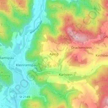
Name: Asing topographic map, elevation, terrain.
Location: Asing, Regenstauf, Landkreis Regensburg, Bavaria, Germany (49.13886 12.14877 49.17886 12.18877)
Average elevation: 1,404 ft
Minimum elevation: 1,076 ft
Maximum elevation: 1,864 ft
Thank you for supporting this site ❤️
Make a donation
Make a donation
Gear up for your next adventure:
As an Amazon Associate, this site earns from qualifying purchases at no extra cost to you.