
Worcester topographic map
Click on the map to display elevation.
Worcester
Worcester is located at an elevation of 220 metres (720 ft) and can be reached by road either travelling on the N1 highway through the Huguenot Tunnel or by driving through spectacular mountain passes. From Cape Town Du Toitskloof, from Wellington Bainskloof, from Malmesbury, Western Cape Nieuwekloof, from Ceres Mitchells, from Robertson Goree, from Hermanus Rooihoogte and from Johannesburg Hex River, with vistas over the Hex River Valley.
About this map
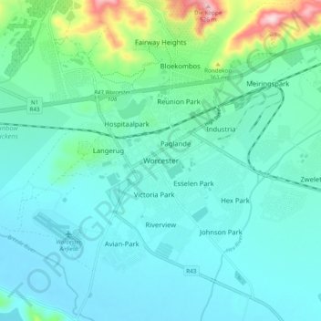
Name: Worcester topographic map, elevation, terrain.
Average elevation: 827 ft
Minimum elevation: 640 ft
Maximum elevation: 1,722 ft
Other topographic maps
Click on a map to view its topography, its elevation and its terrain.
Hex River
South Africa > Western Cape > Cape Winelands District Municipality > Breede Valley Local Municipality
Average elevation: 2,113 ft
Breede River
South Africa > Western Cape > Cape Winelands District Municipality > Breede Valley Local Municipality
Average elevation: 719 ft