
Make a donation
Gear up for your next adventure:
As an Amazon Associate, this site earns from qualifying purchases at no extra cost to you.
Vilcas Huaman topographic map
Click on the map to display elevation.
Make a donation
Gear up for your next adventure:
As an Amazon Associate, this site earns from qualifying purchases at no extra cost to you.
Vilcas Huaman
Vilcashuamán (en quechua: Willkawaman; 'halcón sagrado') es una ciudad peruana, capital del distrito y de la provincia homónimos, ubicada en el departamento de Ayacucho. Está situada a una altitud de 3490 m s. n. m. en la vertiente oriental de la cordillera de los Andes. Está construida sobre un antiguo asentamiento incaico.
Make a donation
Gear up for your next adventure:
As an Amazon Associate, this site earns from qualifying purchases at no extra cost to you.
About this map
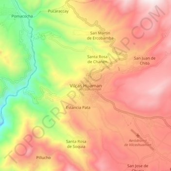
Name: Vilcas Huaman topographic map, elevation, terrain.
Location: Vilcas Huaman, Vilcas Huamán, Ayacucho, Perú (-13.69310 -73.99383 -13.61310 -73.91383)
Average elevation: 11,237 ft
Minimum elevation: 8,622 ft
Maximum elevation: 13,219 ft
Make a donation
Gear up for your next adventure:
As an Amazon Associate, this site earns from qualifying purchases at no extra cost to you.