Geolocate

Muxía topographic map

Click on the map to display elevation.

About this map

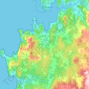
Name: Muxía topographic map, elevation, terrain.

Location: Muxía, Fisterra, A Coruña, Galicia, Spain (43.00105 -9.30154 43.12989 -9.09253)

Average elevation: 233 ft

Minimum elevation: -3 ft

Maximum elevation: 1,070 ft

Gear up for your next adventure:

🧺Microfiber Travel Towels - Compact and fast-drying towels for trail use
🥄Camping Utensil Set - Lightweight utensils for outdoor meals
Camping Coffee Makers - Enjoy premium coffee at the summit or campsite
🚁Photography Drones - Capture stunning aerial views of landforms and topography
🥤Water Filter Bottle - All‑in‑one filter bottle for safe hydration

As an Amazon Associate, this site earns from qualifying purchases at no extra cost to you.