Geolocate

Ostfildern topographic map

Click on the map to display elevation.

About this map

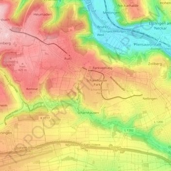
Name: Ostfildern topographic map, elevation, terrain.

Location: Ostfildern, Landkreis Esslingen, Baden-Württemberg, 73760, Germany (48.69467 9.21151 48.74430 9.31194)

Average elevation: 1,148 ft

Minimum elevation: 741 ft

Maximum elevation: 1,490 ft

Other topographic maps

Click on a map to view its topography, its elevation and its terrain.

Balzholz

Germany > Baden-Württemberg > Landkreis Esslingen

Average elevation: 1,535 ft

Jusiberg

Germany > Baden-Württemberg > Landkreis Esslingen > Neuffen

Average elevation: 1,588 ft

Leinfelden

Germany > Baden-Württemberg > Landkreis Esslingen

Average elevation: 1,414 ft

Gear up for your next adventure:

📷Action Cameras - Rugged cameras to document your journeys across rugged terrain
🧤Hiking Gloves - Protective gloves for rugged trails
🧦Merino Wool Socks - Moisture-wicking, blister-preventing socks for long treks
🪶Survival Guide Book - Expert advice for emergency preparedness
🎒Waterproof Dry Bags - Keep your electronics and maps dry inside your pack

As an Amazon Associate, this site earns from qualifying purchases at no extra cost to you.