Geolocate

Bajardo topographic map

Click on the map to display elevation.

Bajardo

Its principal settlement, Bajardo itself, is a medieval village which stands at an elevation of 900 metres (3,000 ft) on a peak at the head of the basin of the Nervia torrent.

Wikipedia (CC-BY-SA 3.0)

About this map

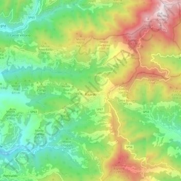
Name: Bajardo topographic map, elevation, terrain.

Location: Bajardo, Provincia di Imperia, Liguria, 18031, Italy (43.86526 7.68489 43.94367 7.77718)

Average elevation: 2,329 ft

Minimum elevation: 512 ft

Maximum elevation: 5,282 ft

Other topographic maps

Click on a map to view its topography, its elevation and its terrain.

Montalto Ligure

Italy > Liguria > Provincia di Imperia

Average elevation: 1,736 ft

Bestagno

Italy > Liguria > Provincia di Imperia > Pontedassio

Average elevation: 899 ft

Gear up for your next adventure:

🔪Outdoor Multitools - Essential survival tools for gear repair and field use
❄️Traction Cleats - Prevent slips on icy trails during winter hikes
🧭Pro Hiking Compasses - High-accuracy liquid-filled compasses for topographic orientation
🥘Titanium Cookware - Durable, featherlight pots and pans for backpacking
🛡️Bear Spray Outdoor - Protection in bear country hikes

As an Amazon Associate, this site earns from qualifying purchases at no extra cost to you.