
Make a donation
Gear up for your next adventure:
As an Amazon Associate, this site earns from qualifying purchases at no extra cost to you.
Hargeisa topographic map
Click on the map to display elevation.
Make a donation
Gear up for your next adventure:
As an Amazon Associate, this site earns from qualifying purchases at no extra cost to you.
Hargeisa
Hargeisa is situated in a valley in the Galgodon (Ogo) highlands, and sits at an elevation of 1,334 m (4,377 ft). Home to rock art from the Neolithic period, the city is also a commercial hub for precious stone-cutting, construction, retail services and trading, among other activities.
Make a donation
Gear up for your next adventure:
As an Amazon Associate, this site earns from qualifying purchases at no extra cost to you.
About this map
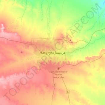
Name: Hargeisa topographic map, elevation, terrain.
Average elevation: 4,229 ft
Minimum elevation: 3,524 ft
Maximum elevation: 4,974 ft
Make a donation
Gear up for your next adventure:
As an Amazon Associate, this site earns from qualifying purchases at no extra cost to you.