Geolocate

Troy topographic map

Click on the map to display elevation.

About this map

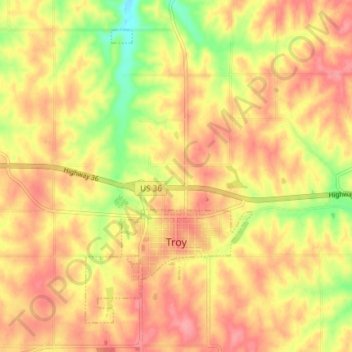
Name: Troy topographic map, elevation, terrain.

Location: Troy, Doniphan County, Kansas, United States (39.77273 -95.14734 39.82002 -95.07369)

Average elevation: 1,086 ft

Minimum elevation: 909 ft

Maximum elevation: 1,194 ft

Doniphan County trails, hiking, mountain biking, running and outdoor activities

Other topographic maps

Click on a map to view its topography, its elevation and its terrain.

Bendena

United States > Kansas > Doniphan County

Average elevation: 1,076 ft

Fanning

United States > Kansas > Doniphan County

Average elevation: 955 ft

Gear up for your next adventure:

🧢Outdoor Hiking Hat - Sun protection hat for outdoor explorers
🔭Stargazing Telescopes - Perfect for camping in low-light pollution areas shown on maps
📶Vehicle Signal Boosters - Improve reception in rural areas while driving to trailheads
🛡️Bear Spray Outdoor - Protection in bear country hikes
🦶Carbon Trekking Poles - Reduce knee impact on steep descents with ultra-light poles

As an Amazon Associate, this site earns from qualifying purchases at no extra cost to you.