Geolocate

Danao topographic map

Click on the map to display elevation.

About this map

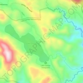
Name: Danao topographic map, elevation, terrain.

Location: Danao, Ormoc, Leyte, Eastern Visayas, 6541, Philippines (11.05212 124.68095 11.09212 124.72095)

Average elevation: 2,310 ft

Minimum elevation: 1,617 ft

Maximum elevation: 3,363 ft

Other topographic maps

Click on a map to view its topography, its elevation and its terrain.

Ormoc City Proper

Philippines > Leyte > Ormoc

Average elevation: 59 ft

Binahaan River

Philippines > Leyte > Ormoc

Average elevation: 1,791 ft

Binahaan River

Philippines > Leyte > Ormoc

Average elevation: 1,624 ft

Gear up for your next adventure:

🧭Hiking Compass - Precision compass for reliable navigation in the wilderness
🧦Merino Wool Socks - Moisture-wicking, blister-preventing socks for long treks
Camping Coffee Makers - Enjoy premium coffee at the summit or campsite
🏫Relief Map Kits - Hands-on tools for teaching landforms and elevation
🏕️Family Camping Gear - Essentials for group camping trips

As an Amazon Associate, this site earns from qualifying purchases at no extra cost to you.