
Make a donation
Gear up for your next adventure:
As an Amazon Associate, this site earns from qualifying purchases at no extra cost to you.
Épisy topographic map
Click on the map to display elevation.
Make a donation
Gear up for your next adventure:
As an Amazon Associate, this site earns from qualifying purchases at no extra cost to you.
Épisy
La commune est classée en zone de sismicité 1, correspondant à une sismicité très faible. L'altitude varie de 50 mètres à 88 mètres pour le point le plus haut , le centre du bourg se situant à environ 53 mètres d'altitude (mairie).
Make a donation
Gear up for your next adventure:
As an Amazon Associate, this site earns from qualifying purchases at no extra cost to you.
About this map
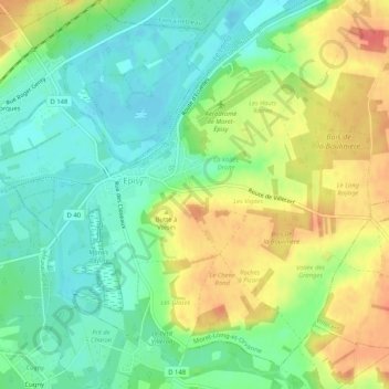
Name: Épisy topographic map, elevation, terrain.
Average elevation: 226 ft
Minimum elevation: 148 ft
Maximum elevation: 335 ft
Make a donation
Gear up for your next adventure:
As an Amazon Associate, this site earns from qualifying purchases at no extra cost to you.
Other topographic maps
Click on a map to view its topography, its elevation and its terrain.