
Thank you for supporting this site ❤️
Make a donation
Make a donation
Gear up for your next adventure:
As an Amazon Associate, this site earns from qualifying purchases at no extra cost to you.
Rosée topographic map
Click on the map to display elevation.
Thank you for supporting this site ❤️
Make a donation
Make a donation
Gear up for your next adventure:
As an Amazon Associate, this site earns from qualifying purchases at no extra cost to you.
About this map
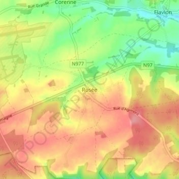
Name: Rosée topographic map, elevation, terrain.
Location: Rosée, Florennes, Philippeville, Namen, Wallonië, 5620, België (50.21230 4.66766 50.25230 4.70766)
Average elevation: 922 ft
Minimum elevation: 764 ft
Maximum elevation: 1,050 ft
Thank you for supporting this site ❤️
Make a donation
Make a donation
Gear up for your next adventure:
As an Amazon Associate, this site earns from qualifying purchases at no extra cost to you.
Other topographic maps
Click on a map to view its topography, its elevation and its terrain.
Hemptinne
België > Namen > Philippeville > Florennes
De hoogte aan de kerk bedraagt 245 meter
Average elevation: 856 ft