Geolocate

Rockbridge topographic map

Click on the map to display elevation.

About this map

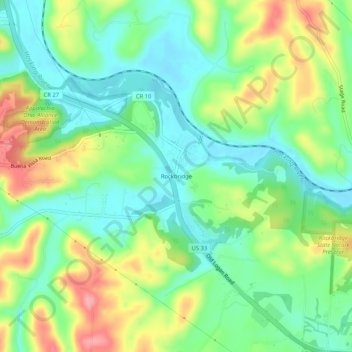
Name: Rockbridge topographic map, elevation, terrain.

Location: Rockbridge, Hocking County, Ohio, 43149, United States (39.55979 -82.54210 39.59979 -82.50210)

Average elevation: 860 ft

Minimum elevation: 732 ft

Maximum elevation: 1,079 ft

Hocking County trails, hiking, mountain biking, running and outdoor activities

Other topographic maps

Click on a map to view its topography, its elevation and its terrain.

Murray City

United States > Ohio > Hocking County

Average elevation: 843 ft

Rose Lake

United States > Ohio > Hocking County

Average elevation: 968 ft

Logan

United States > Ohio > Hocking County

Average elevation: 833 ft

Rose Lake Dam

United States > Ohio > Hocking County

Average elevation: 974 ft

Gear up for your next adventure:

🛌Ultralight Sleeping Bags - Compact down bags for cold nights in the wilderness
🛠️Backpacking Tool Kit - Essential toolkit for outdoor repairs
🔋Solar Power Banks - Keep your GPS and phone charged in remote wilderness areas
🌧️Backpack Rain Cover - Keep gear dry in wet weather
📡Handheld GPS Device - Reliable handheld GPS for outdoor navigation

As an Amazon Associate, this site earns from qualifying purchases at no extra cost to you.