
Valsad topographic map
Click on the map to display elevation.
About this map
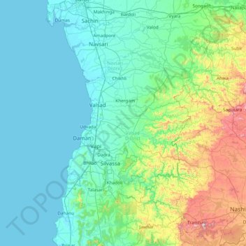
Name: Valsad topographic map, elevation, terrain.
Location: Valsad, Valsad District, Gujarat, India (19.80000 72.38333 21.20000 73.78333)
Average elevation: 577 ft
Minimum elevation: -7 ft
Maximum elevation: 4,170 ft
Other topographic maps
Click on a map to view its topography, its elevation and its terrain.
Gandhinagar
India > Gujarat > Gandhinagar Taluka
Gandhinagar has an average elevation of 81 metres (266 feet). The city sits on the banks of the Sabarmati River, in north-central-east Gujarat. The 20,543 km2 area around Gandhinagar is defined by Gujarat capital territory. Gandhinagar spans an area of 326 km2 (126 sq mi). The river frequently dries up in the…
Average elevation: 246 ft