
Make a donation
Gear up for your next adventure:
As an Amazon Associate, this site earns from qualifying purchases at no extra cost to you.
el Rebolledo topographic map
Click on the map to display elevation.
Make a donation
Gear up for your next adventure:
As an Amazon Associate, this site earns from qualifying purchases at no extra cost to you.
About this map
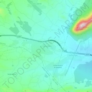
Name: el Rebolledo topographic map, elevation, terrain.
Average elevation: 489 ft
Minimum elevation: 253 ft
Maximum elevation: 1,457 ft
Make a donation
Gear up for your next adventure:
As an Amazon Associate, this site earns from qualifying purchases at no extra cost to you.
Other topographic maps
Click on a map to view its topography, its elevation and its terrain.
Isla de Tabarca
España > Comunidad Valenciana > Alicante > Tabarca
La isla abarca una superficie total de 30 ha, con una longitud máxima de 1.850 m de NO a SE y una anchura máxima de 450 m. Presenta un importante estrechamiento en su tercio oeste, donde se sitúan el puerto y las dos playas, lo cual crea un istmo que separa la ciudad del resto de la isla. Su relieve…
Average elevation: 0 ft
Make a donation
Gear up for your next adventure:
As an Amazon Associate, this site earns from qualifying purchases at no extra cost to you.