Geolocate

Upland topographic map

Click on the map to display elevation.

About this map

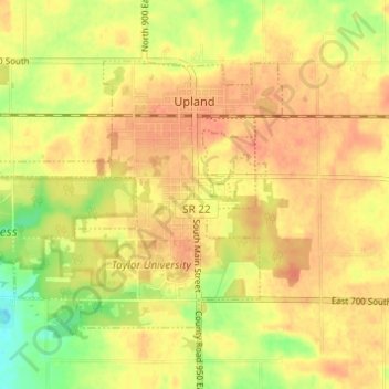
Name: Upland topographic map, elevation, terrain.

Location: Upland, Grant County, Indiana, 46989, United States (40.44847 -85.54168 40.48039 -85.48063)

Average elevation: 912 ft

Minimum elevation: 820 ft

Maximum elevation: 955 ft

Grant County trails, hiking, mountain biking, running and outdoor activities

Other topographic maps

Click on a map to view its topography, its elevation and its terrain.

Jalapa

United States > Indiana > Grant County

Average elevation: 810 ft

Gear up for your next adventure:

🖼️Topo Map Wall Art - Decorative topographic prints of famous peaks and regions
🔭Stargazing Telescopes - Perfect for camping in low-light pollution areas shown on maps
🪶Camp Gear Gift Set - Perfect gift bundle for outdoor fans
🧭Map Reading Tools - Tools and kits for map navigation
🌧️Backpack Rain Cover - Keep gear dry in wet weather

As an Amazon Associate, this site earns from qualifying purchases at no extra cost to you.