Geolocate

Patpat topographic map

Click on the map to display elevation.

About this map

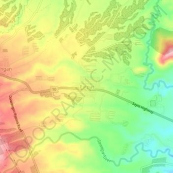
Name: Patpat topographic map, elevation, terrain.

Location: Patpat, Malaybalay, Bukidnon, Northern Mindanao, Philippines (8.17619 125.04375 8.21619 125.08375)

Average elevation: 2,769 ft

Minimum elevation: 2,493 ft

Maximum elevation: 3,041 ft

Other topographic maps

Click on a map to view its topography, its elevation and its terrain.

Kulaman River

Philippines > Bukidnon > Malaybalay

Average elevation: 2,444 ft

Gear up for your next adventure:

📚USA Hiking Guide Books - Top trail guides and map books
GPS Sports Watch - GPS watch for running, hiking and training
🛰️Handheld GPS Units - Professional satellite navigators for precise backcountry mapping
🪵Folding Camp Saw - Compact saw for wood and campsite work
🧭Compass with Lanyard - Easy‑carry compass for navigation

As an Amazon Associate, this site earns from qualifying purchases at no extra cost to you.