
Make a donation
Gear up for your next adventure:
As an Amazon Associate, this site earns from qualifying purchases at no extra cost to you.
Stoneville topographic map
Click on the map to display elevation.
Make a donation
Gear up for your next adventure:
As an Amazon Associate, this site earns from qualifying purchases at no extra cost to you.
About this map
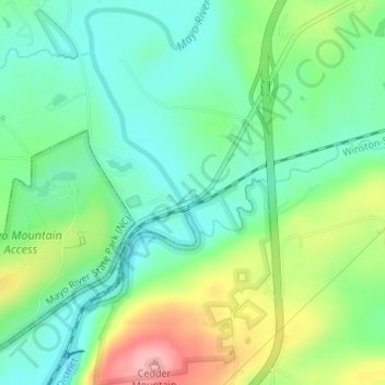
Name: Stoneville topographic map, elevation, terrain.
Location: Stoneville, Rockingham County, North Carolina, United States (36.43923 -79.93755 36.43977 -79.93687)
Average elevation: 732 ft
Minimum elevation: 594 ft
Maximum elevation: 997 ft
Rockingham County trails, hiking, mountain biking, running and outdoor activities
Make a donation
Gear up for your next adventure:
As an Amazon Associate, this site earns from qualifying purchases at no extra cost to you.
Other topographic maps
Click on a map to view its topography, its elevation and its terrain.
Forest Hills
United States > North Carolina > Rockingham County > Reidsville > Forest Hills
Average elevation: 771 ft
Make a donation
Gear up for your next adventure:
As an Amazon Associate, this site earns from qualifying purchases at no extra cost to you.
Sandy Cross
United States > North Carolina > Rockingham County > Sandy Cross
Average elevation: 810 ft