Geolocate

Holly topographic map

Click on the map to display elevation.

About this map

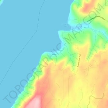
Name: Holly topographic map, elevation, terrain.

Location: Holly, Kitsap County, Washington, United States (47.53759 -122.99849 47.57759 -122.95849)

Average elevation: 194 ft

Minimum elevation: -3 ft

Maximum elevation: 646 ft

Kitsap County trails, hiking, mountain biking, running and outdoor activities

Other topographic maps

Click on a map to view its topography, its elevation and its terrain.

Keyport

United States > Washington > Kitsap County > Keyport

Average elevation: 52 ft

Hood Canal

United States > Washington > Kitsap County > Port Gamble

Average elevation: 942 ft

Manchester

United States > Washington > Kitsap County

Average elevation: 138 ft

Tracyton

United States > Washington > Kitsap County > Tracyton

Average elevation: 157 ft

Blake Island

United States > Washington > Kitsap County

Average elevation: 30 ft

Seabeck Creek

United States > Washington > Kitsap County

Average elevation: 354 ft

Gear up for your next adventure:

💧Water Purification System - Clean water on the trail with reliable purifiers
🪑Ultralight Camp Chairs - Portable seating for resting after a long day of mapping
🔥Plasma Lighters - Windproof lighters that work in any weather condition
🧼Biodegradable Camping Soap - Eco‑friendly soap for outdoor hygiene
🦟Ultrasonic Repellers - Create a bug-free zone at your camp or rest stop

As an Amazon Associate, this site earns from qualifying purchases at no extra cost to you.