Geolocate

Marlow topographic map

Click on the map to display elevation.

About this map

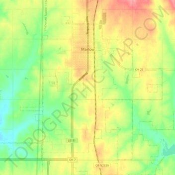
Name: Marlow topographic map, elevation, terrain.

Location: Marlow, Stephens County, Oklahoma, 73055, United States (34.58703 -97.99750 34.67147 -97.91404)

Average elevation: 1,263 ft

Minimum elevation: 1,135 ft

Maximum elevation: 1,398 ft

Stephens County trails, hiking, mountain biking, running and outdoor activities

Other topographic maps

Click on a map to view its topography, its elevation and its terrain.

Countyline

United States > Oklahoma > Stephens County

Average elevation: 1,017 ft

Gear up for your next adventure:

📡Handheld GPS Device - Reliable handheld GPS for outdoor navigation
🍳Camping Cook Set - Complete cookware for outdoor meals
🌎3D Topographic Globes - Raised relief globes for a tactile understanding of geography
🚑Emergency Bivvies - Heat-reflective sleeping bags for survival situations
🧭Compass with Lanyard - Easy‑carry compass for navigation

As an Amazon Associate, this site earns from qualifying purchases at no extra cost to you.