
Bloomfield topographic map
Click on the map to display elevation.
About this map
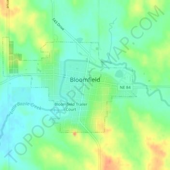
Name: Bloomfield topographic map, elevation, terrain.
Location: Bloomfield, Knox County, Nebraska, 68718, United States (42.59044 -97.66342 42.60563 -97.63442)
Average elevation: 1,729 ft
Minimum elevation: 1,673 ft
Maximum elevation: 1,824 ft
Knox County trails, hiking, mountain biking, running and outdoor activities
Other topographic maps
Click on a map to view its topography, its elevation and its terrain.
Bloomfield Trailer Court
United States > Nebraska > Knox County > Bloomfield
Average elevation: 1,739 ft