Geolocate

Rasch topographic map

Click on the map to display elevation.

About this map

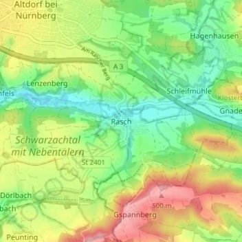
Name: Rasch topographic map, elevation, terrain.

Location: Rasch, Altdorf bei Nürnberg, Landkreis Nürnberger Land, Bayern, 90518, Deutschland (49.34730 11.35814 49.38730 11.39814)

Average elevation: 1,394 ft

Minimum elevation: 1,198 ft

Maximum elevation: 1,670 ft

Other topographic maps

Click on a map to view its topography, its elevation and its terrain.

Gear up for your next adventure:

🧭Compass with Lanyard - Easy‑carry compass for navigation
🥩Freeze-Dried Meals - Nutritious and lightweight food for remote expeditions
👓Polarized Sunglasses - Outdoor sunglasses for glare reduction
🚁Photography Drones - Capture stunning aerial views of landforms and topography
🪶Survival Guide Book - Expert advice for emergency preparedness

As an Amazon Associate, this site earns from qualifying purchases at no extra cost to you.