Geolocate

Guin topographic map

Click on the map to display elevation.

About this map

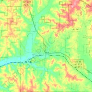
Name: Guin topographic map, elevation, terrain.

Location: Guin, Marion County, Alabama, 35563, United States (33.91954 -87.94386 34.03016 -87.87616)

Average elevation: 551 ft

Minimum elevation: 377 ft

Maximum elevation: 810 ft

Marion County trails, hiking, mountain biking, running and outdoor activities

Other topographic maps

Click on a map to view its topography, its elevation and its terrain.

Shottsville

United States > Alabama > Marion County

Average elevation: 528 ft

Bear Creek

United States > Alabama > Marion County > Hackleburg

Average elevation: 853 ft

Gear up for your next adventure:

🗃️Trail First Aid Kit - Essential kit for outdoor injuries and emergencies
👖Convertible Hiking Pants - Versatile zip-off pants for changing altitudes and temperatures
🏕️Family Camping Gear - Essentials for group camping trips
🪶LED Camping Lantern - Bright lantern for camp lighting
🪶Survival Guide Book - Expert advice for emergency preparedness

As an Amazon Associate, this site earns from qualifying purchases at no extra cost to you.