
Hailsham topographic map
Click on the map to display elevation.
About this map
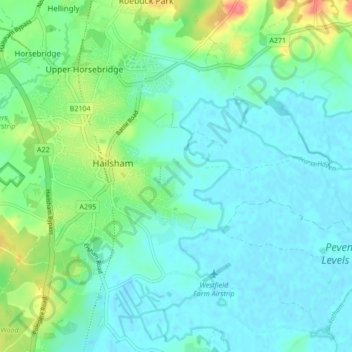
Name: Hailsham topographic map, elevation, terrain.
Location: Hailsham, Wealden, East Sussex, England, United Kingdom (50.83609 0.23526 50.88954 0.30873)
Average elevation: 46 ft
Minimum elevation: -3 ft
Maximum elevation: 190 ft
Other topographic maps
Click on a map to view its topography, its elevation and its terrain.
Ashdown Forest
United Kingdom > England > East Sussex > Wealden
Ashdown Forest is an ancient area of open heathland occupying the highest sandy ridge-top of the High Weald Area of Outstanding Natural Beauty. It is situated 30 miles (48 km) south of London in the county East Sussex, England. Rising to an elevation of 732 feet (223 m) above sea level, its heights provide…
Average elevation: 384 ft
Colemans Hatch
United Kingdom > England > East Sussex > Wealden > Upper Hartfield
Average elevation: 322 ft
Punnetts Town Recreation Ground
United Kingdom > England > East Sussex > Wealden > Punnett's Town > Chapel Cross
Average elevation: 410 ft
Frant Lakes
United Kingdom > England > East Sussex > Wealden > Bells Yew Green
Average elevation: 361 ft
Heathfield Park
United Kingdom > England > East Sussex > Wealden > Cade Street
Average elevation: 433 ft
Old Heathfield
United Kingdom > England > East Sussex > Wealden > Cade Street
Average elevation: 390 ft
Broadwater Warren Nature Reserve
United Kingdom > England > East Sussex > Wealden > Groombridge
Average elevation: 276 ft
Chuck Hatch
United Kingdom > England > East Sussex > Wealden > Upper Hartfield
Average elevation: 367 ft
Sheffield Green
United Kingdom > England > East Sussex > Wealden > Sheffield Park
Average elevation: 164 ft
Best Beech Hill
United Kingdom > England > East Sussex > Wealden > Best Beech Hill
Average elevation: 394 ft