Geolocate

Lamao topographic map

Click on the map to display elevation.

About this map

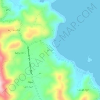
Name: Lamao topographic map, elevation, terrain.

Location: Lamao, Romblon, Mimaropa, 5500, Philippines (12.53823 122.28504 12.57823 122.32504)

Average elevation: 289 ft

Minimum elevation: -3 ft

Maximum elevation: 1,158 ft

Other topographic maps

Click on a map to view its topography, its elevation and its terrain.

Alad

Philippines > Romblon > Romblon

Average elevation: 33 ft

Logbon Island

Philippines > Romblon > Romblon > Logbon

Average elevation: 10 ft

Gear up for your next adventure:

👓Polarized Sunglasses - Outdoor sunglasses for glare reduction
🩳Quick‑Dry Hiking Shorts - Comfortable and quick‑dry shorts for summer hiking
🛏️Cold Weather Sleeping Bag - Warm sleeping bag for cold conditions
🎒Gear Packing Cubes - Organize your backpack efficiently
Solar GPS Watches - Advanced multisport watches with built-in topographic maps

As an Amazon Associate, this site earns from qualifying purchases at no extra cost to you.