
Buxton topographic map
Interactive map
Click on the map to display elevation.
About this map
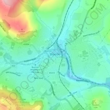
Name: Buxton topographic map, elevation, terrain.
Location: Buxton, High Peak, Derbyshire, England, United Kingdom (53.24499 -1.93022 53.27317 -1.88366)
Average elevation: 1,096 ft
Minimum elevation: 935 ft
Maximum elevation: 1,509 ft
Buxton has an oceanic climate with short, mild summers and long, cool winters. At about 1,000 feet (300 m) above sea level, As the highest market town in England, Buxton's elevation makes it cooler and wetter than surrounding towns, with a daytime temperature typically about 2 °C lower than Manchester.
Other topographic maps
Click on a map to view its topography, its elevation and its terrain.
Hadfield
United Kingdom > England > Derbyshire > High Peak
Hadfield, High Peak, Derbyshire, England, United Kingdom
Average elevation: 571 ft
Lose Hill
United Kingdom > England > Derbyshire > High Peak
Lose Hill, High Peak, Derbyshire, England, S33 8WB, United Kingdom
Average elevation: 869 ft
Mam Tor
United Kingdom > England > Derbyshire > High Peak
Mam Tor, High Peak, Derbyshire, East Midlands, England, S33 8WA, United Kingdom
Average elevation: 1,138 ft
Castleton
United Kingdom > England > Derbyshire > High Peak
Castleton, High Peak, Derbyshire, England, United Kingdom
Average elevation: 1,070 ft