
Make a donation
Gear up for your next adventure:
As an Amazon Associate, this site earns from qualifying purchases at no extra cost to you.
Castleton topographic map
Click on the map to display elevation.
Make a donation
Gear up for your next adventure:
As an Amazon Associate, this site earns from qualifying purchases at no extra cost to you.
About this map
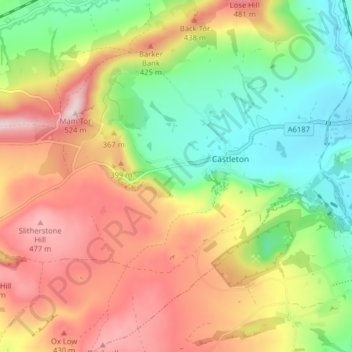
Name: Castleton topographic map, elevation, terrain.
Location: Castleton, High Peak, Derbyshire, England, United Kingdom (53.31701 -1.81804 53.36445 -1.75896)
Average elevation: 1,070 ft
Minimum elevation: 551 ft
Maximum elevation: 1,667 ft
Make a donation
Gear up for your next adventure:
As an Amazon Associate, this site earns from qualifying purchases at no extra cost to you.
Other topographic maps
Click on a map to view its topography, its elevation and its terrain.
Birch Vale
United Kingdom > England > Derbyshire > High Peak > New Mills > Hayfield
Average elevation: 823 ft
Make a donation
Gear up for your next adventure:
As an Amazon Associate, this site earns from qualifying purchases at no extra cost to you.