Geolocate

Hadfield topographic map

Click on the map to display elevation.

About this map

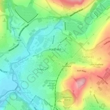
Name: Hadfield topographic map, elevation, terrain.

Location: Hadfield, High Peak, Derbyshire, England, United Kingdom (53.45706 -1.98808 53.46886 -1.96043)

Average elevation: 571 ft

Minimum elevation: 387 ft

Maximum elevation: 892 ft

Other topographic maps

Click on a map to view its topography, its elevation and its terrain.

Glossop

United Kingdom > England > Derbyshire > High Peak

Average elevation: 932 ft

Dove Holes

United Kingdom > England > Derbyshire > High Peak

Average elevation: 1,171 ft

Birch Vale

United Kingdom > England > Derbyshire > High Peak > New Mills > Hayfield

Average elevation: 823 ft

Lose Hill

United Kingdom > England > Derbyshire > High Peak

Average elevation: 869 ft

Mam Tor

United Kingdom > England > Derbyshire > High Peak

Average elevation: 1,138 ft

Gear up for your next adventure:

🪶Camp Gear Gift Set - Perfect gift bundle for outdoor fans
🦟Ultrasonic Repellers - Create a bug-free zone at your camp or rest stop
🥘Titanium Cookware - Durable, featherlight pots and pans for backpacking
🧣Hiking Neck Gaiter - Multi‑use neck protection for outdoor weather
🧷Carabiner Set - Durable clips for gear attachment

As an Amazon Associate, this site earns from qualifying purchases at no extra cost to you.