
Thank you for supporting this site ❤️
Make a donation
Make a donation
Gear up for your next adventure:
As an Amazon Associate, this site earns from qualifying purchases at no extra cost to you.
Oberense topographic map
Click on the map to display elevation.
Thank you for supporting this site ❤️
Make a donation
Make a donation
Gear up for your next adventure:
As an Amazon Associate, this site earns from qualifying purchases at no extra cost to you.
About this map
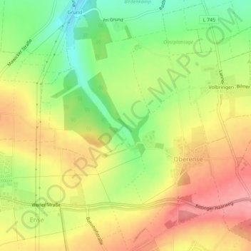
Name: Oberense topographic map, elevation, terrain.
Location: Oberense, Ense, Kreis Soest, Nordrhein-Westfalen, Deutschland (51.49960 7.97293 51.52469 8.01083)
Average elevation: 643 ft
Minimum elevation: 469 ft
Maximum elevation: 801 ft
Thank you for supporting this site ❤️
Make a donation
Make a donation
Gear up for your next adventure:
As an Amazon Associate, this site earns from qualifying purchases at no extra cost to you.