Geolocate

Bebeladan topographic map

Click on the map to display elevation.

About this map

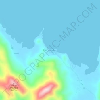
Name: Bebeladan topographic map, elevation, terrain.

Location: Bebeladan, El Nido, Palawan, Mimaropa, Philippines (11.01930 119.36416 11.05930 119.40416)

Average elevation: 154 ft

Minimum elevation: 0 ft

Maximum elevation: 1,125 ft

Other topographic maps

Click on a map to view its topography, its elevation and its terrain.

Lio Beach

Philippines > Palawan > El Nido > Villa Libertad

Average elevation: 43 ft

Corong Beach

Philippines > Palawan > El Nido

Average elevation: 164 ft

Gear up for your next adventure:

🥘Titanium Cookware - Durable, featherlight pots and pans for backpacking
🚑Emergency Bivvies - Heat-reflective sleeping bags for survival situations
🖼️Topo Map Wall Art - Decorative topographic prints of famous peaks and regions
🛠️Outdoor Gear Repair Kit - Essential tools to fix gear on the trail
❄️Traction Cleats - Prevent slips on icy trails during winter hikes

As an Amazon Associate, this site earns from qualifying purchases at no extra cost to you.