
Steinwiesen topographic map
Interactive map
Click on the map to display elevation.
About this map
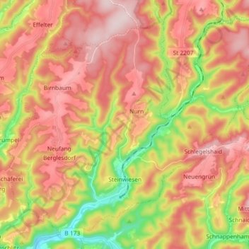
Name: Steinwiesen topographic map, elevation, terrain.
Location: Steinwiesen, Landkreis Kronach, Bayern, 96349, Deutschland (50.27833 11.39641 50.36035 11.54117)
Average elevation: 1,693 ft
Minimum elevation: 1,119 ft
Maximum elevation: 2,133 ft
Berglesdorf | Birnbaum | Eisenhammer | Erlabrück | Hubertushöhe | Klingersmühle | Kochsmühle | Kübelberg | Leitsch | Leitschenstein | Löfflersmühle | Neufang | Nurn | Remitzhof | Rieblich | Schlegelshaid | Schnabrichsmühle | Schwarzmühle | Steinwiesen | Teichmühle | Tempenberg
Other topographic maps
Click on a map to view its topography, its elevation and its terrain.
Wallenfels
Deutschland > Bayern > Landkreis Kronach
Wallenfels, Landkreis Kronach, Bayern, 96346, Deutschland
Average elevation: 1,640 ft
Kronach
Deutschland > Bayern > Landkreis Kronach
Kronach, Landkreis Kronach, Bayern, 96317, Deutschland
Average elevation: 1,293 ft