
Wallenfels topographic map
Interactive map
Click on the map to display elevation.
About this map
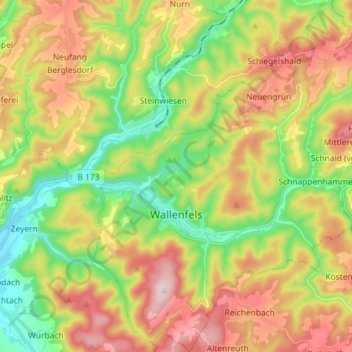
Name: Wallenfels topographic map, elevation, terrain.
Location: Wallenfels, Landkreis Kronach, Bayern, 96346, Deutschland (50.23312 11.43329 50.32514 11.56620)
Average elevation: 1,640 ft
Minimum elevation: 1,089 ft
Maximum elevation: 2,333 ft
Other topographic maps
Click on a map to view its topography, its elevation and its terrain.
Steinwiesen
Deutschland > Bayern > Landkreis Kronach
Steinwiesen, Landkreis Kronach, Bayern, 96349, Deutschland
Average elevation: 1,693 ft
Kronach
Deutschland > Bayern > Landkreis Kronach
Kronach, Landkreis Kronach, Bayern, 96317, Deutschland
Average elevation: 1,293 ft