
Millwood topographic map
Click on the map to display elevation.
About this map
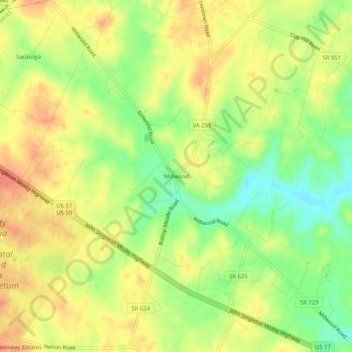
Name: Millwood topographic map, elevation, terrain.
Location: Millwood, Clarke County, Virginia, 22620, United States (39.04955 -78.05778 39.08955 -78.01778)
Average elevation: 548 ft
Minimum elevation: 449 ft
Maximum elevation: 627 ft
Clarke County trails, hiking, mountain biking, running and outdoor activities
Other topographic maps
Click on a map to view its topography, its elevation and its terrain.
University of Virginia Blandy Experimental Farm and Virginia State Arboretum
United States > Virginia > Clarke County > Boyce > Greenway Estates
Average elevation: 594 ft