Geolocate

Friesland topographic map

Click on the map to display elevation.

About this map

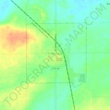
Name: Friesland topographic map, elevation, terrain.

Location: Friesland, Columbia County, Wisconsin, United States (43.58025 -89.07717 43.59612 -89.05676)

Average elevation: 1,001 ft

Minimum elevation: 945 ft

Maximum elevation: 1,076 ft

Columbia County trails, hiking, mountain biking, running and outdoor activities

Other topographic maps

Click on a map to view its topography, its elevation and its terrain.

Fall River

United States > Wisconsin > Columbia County

Average elevation: 873 ft

Dekorra

United States > Wisconsin > Columbia County

Average elevation: 850 ft

Lake Wisconsin

United States > Wisconsin > Columbia County

Average elevation: 794 ft

Englewood

United States > Wisconsin > Columbia County

Average elevation: 906 ft

Lake Columbia

United States > Wisconsin > Columbia County

Average elevation: 791 ft

Gear up for your next adventure:

👟Men's Trail Runners - Lightweight footwear for fast-paced exploration and light hiking
⛑️Personal Locator Beacon - Safety beacon for emergencies
🚁Photography Drones - Capture stunning aerial views of landforms and topography
🔥Camping Stove - Portable stove for camping and backcountry cooking
🪶LED Camping Lantern - Bright lantern for camp lighting

As an Amazon Associate, this site earns from qualifying purchases at no extra cost to you.