
Make a donation
Gear up for your next adventure:
As an Amazon Associate, this site earns from qualifying purchases at no extra cost to you.
Pietracupa topographic map
Click on the map to display elevation.
Make a donation
Gear up for your next adventure:
As an Amazon Associate, this site earns from qualifying purchases at no extra cost to you.
About this map
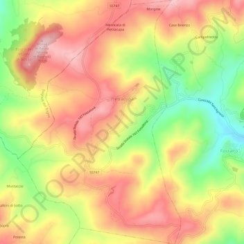
Name: Pietracupa topographic map, elevation, terrain.
Location: Pietracupa, Campobasso, Molise, Italia (41.65569 14.49353 41.70068 14.53379)
Average elevation: 2,037 ft
Minimum elevation: 1,407 ft
Maximum elevation: 2,543 ft
Make a donation
Gear up for your next adventure:
As an Amazon Associate, this site earns from qualifying purchases at no extra cost to you.
Other topographic maps
Click on a map to view its topography, its elevation and its terrain.
Make a donation
Gear up for your next adventure:
As an Amazon Associate, this site earns from qualifying purchases at no extra cost to you.
Make a donation
Gear up for your next adventure:
As an Amazon Associate, this site earns from qualifying purchases at no extra cost to you.
Decontra di Sant'Angelo Limosano
Italia > Molise > Campobasso > Sant'Angelo Limosano
Average elevation: 2,490 ft